
the University of Minnesota Messenia Expedition. In 1992-1995, parts ofwestern Messenia were reexamined still more intensively by the Pylos Regional Archaeological Project. All these endeavors now allow the Palace of Nestor to be viewed in its regional context.
 The
Palace of Nestor is today approached from the parking lot to its
southeast, but in ancient times the main route from the west coast may
have followed the valley bottom to the north, not the course of the
asphalt road to Chora. A chainlink fence encloses the principal palatial
buildings but excludes less monumental remnants of the surrounding
settlement. Relationships between this "Lower Town' and the cemeteries
associated with the Palace of Nestor are clear. The chamber tombs
mentioned by Blegen and Rawson were dug near the edge of the settlement;
the remains of other tombs have been located in the intervening years.
In contrast, Tholos IV lay well within the limits of the later Mycenaean
town. All three tholos tombs were built at a time when the settlement
was smaller and less compact, several centuries before the Palace of
Nestor.
The
Palace of Nestor is today approached from the parking lot to its
southeast, but in ancient times the main route from the west coast may
have followed the valley bottom to the north, not the course of the
asphalt road to Chora. A chainlink fence encloses the principal palatial
buildings but excludes less monumental remnants of the surrounding
settlement. Relationships between this "Lower Town' and the cemeteries
associated with the Palace of Nestor are clear. The chamber tombs
mentioned by Blegen and Rawson were dug near the edge of the settlement;
the remains of other tombs have been located in the intervening years.
In contrast, Tholos IV lay well within the limits of the later Mycenaean
town. All three tholos tombs were built at a time when the settlement
was smaller and less compact, several centuries before the Palace of
Nestor.Several other Mycenaean sites are located only short ' distances from the Palace of Nestor and are worth a brief visit. We provide directions to those that are officially open to the public and are marked by signs. Several other contemporary sites are mentioned in passing.
 Figure 32. Tholos tomb at Charatsari
Koryphasion The low ridge called Beylerbey rises to the south of the village of Koryphasion (Fig. 31). Christo-philopoulos brought this important Mycenaean site to the attention of Blegen, who visited it before beginning excava¬tions at the Palace of Nestor. Many years later Marinatos found that the ridge is badly eroded and that soft marl bedrock lies almost immediately beneath the plowzone. But members of the Pylos Regional Archaeological Project have been able to estimate that settlement once covered five hectares (12 acres), an area a quarter as great as that associated with the Palace of Nestor.
North of Beylerbey on the outskirts of Koryphasion, one can locate with some difficulty the tholos at Charatsari, excavated in 1926 by Kourouniotis (Fig. 32).19 The latest pottery dates to the 15th century B.C.
The tholos tomb appears to have been built toward or at the end of the Middle Bronze Age (ca. 1680 B.C.) and is thus the earliest of its type yet discovered in Greece. The tomb is located in a flat field, almost entirely buried underground. Dead were buried in pits and in large jars, the former with lavish offerings of vessels in precious metals and bronze weapons.

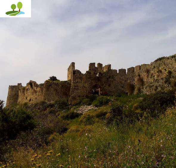
Figure 33. Palaionavarino and Cave of Nestor from Voidokoilia
Voidokoilia The shallow sea inlet surrounded by sand dunes west of Osmanaga Lagoon is called Voidokoilia (in Greek, "ox-belly") Bay because of its distinctive shape.20 At its western side rises the medieval fortress of Pylos at Palaionavarino (Old Navarino). On its northern slope, in the so-called Cave of Nestor (Fig. 33), excavations have recovered Neolithic pottery of the 4th millennium B.C. and of the Mycenaean period. On the rocky headland at the south end of Voidokoilia Bay are preserved the foun¬dations of buildings that belong to the ancient Greek set¬tlement of Coryphasion.21 Mycenaean pottery has been found beneath them, in the hollows of the bedrock.

Figure 34. Voidokoilia from Palaionavarino
For much more impressive prehistoric remains, visit the headland at the north end of Voidokoilia Bay (Fig. 34). Here Marinatos unearthed a small Early Mycenaean tholos tomb. Pausanias, a Greek traveler who visited the area in the 2nd century A.c, mentions a "monument" of Thrasyme-des, one of the sons of King Nestor, and Marinatos believed that this was his final resting place. Two human skeletons remained inside; the complete carcass of a cow appears to have been included as a grave gift. Recent excavations by George Korres of the University of Athens have now de¬monstrated that the tholos tomb was set into the remnants of a small Early Bronze Age village, dating to the later 3rd millennium B.C. Obsidian from the Cycladic island of Melos found in its buildings demonstrates the existence of trade and contact with the wider Aegean world. At the end of the 3rd millennium B.C. the promontory was transformed into a cemetery. Eventually a circular mound of earth and rubble about 1.5 m (nearly 5 feet) high was heaped up over the walls of the settlement and large jars were set into it as containers for human remains.
Romanou Traces of Mycenaean occupation have been found within the modern town of Romanou. A short distance to the northwest, a large flat-bottomed rectangu¬lar basin, ca. 200 χ 300 m (650 χ 975 feet) in a bend of the Selas River may have been the port of the Palace of Nestor in Mycenaean times, but is now entirely filled with silt.
Northeast of the village of Romanou, a low hill called Viglitsa affords a commanding view of the coast. Two early Mycenaean tholos tombs were built there (Fig. 35).
Figure 35. Interior of tholos at Viglitsa

Korres has recently clarified the history of this important site. The tombs appear to have been set into remains of earlier settlements, with traces of occupation of the 3rd and earlier 2nd millennium B.C. The earlier of the two tholos tombs was built in the 16th century the second slightly later. Finds from the tombs include a seal depicting a winged griffin and a terracotta box of the 12th century B.C. with a rare representation of a prehistoric Greek warship.
Tragana The village of Tragana sits near the western end of one of the principal ridges that slope down to the sea from the foothills of Mount Aigaleon. On its outskirts Ma-rinatos excavated one room of a house that contained finds exclusively of the Early Mycenaean period.23 The room con¬tained triton shells and more than one hundred pottery ves¬sels. Investigations by the Pylos Regional Archaeological Project suggest that this structure did not belong to a larger village or town. It is possible that the room was part of an isolated mansion, long abandoned by the time the Palace of Nestor was built.

Chora The town of Chora is strategically situated at the junction of the ridge of Englianos and the expanse of flatter tableland that sits at the foot of Mount Aigaleon. It commands the only convenient routes leading north, south, or east from the Palace of Nestor. The earliest traces of occupation at Chora (4th millennium B.C.) were found by Marinatos in a cave called Katavothra not far south of the town square. Mycenaean remains are concentrated in the suburb known as Volimidia, along the asphalt road that leads ultimately to the village of Vlachopoulo. In 1953 Marinatos found occupation deposits contemporary with the Palace of Nestor and from Early Mycenaean times. He suspected that there had been a prosperous Mycenaean town at Voli¬midia. No true tholos tombs were ever built there. The site is best known for large chamber tombs, a third of them built already in the 16th century B.C. (Fig. 36). Many were reused in historical times.24
Myrsinochori The village of Myrsinochori is separated by a deep gorge from the uplands around Chora. Northeast of the village an earthen track leads along the ridge of Routsi
to the village of Metamorphosis. No Mycenaean settlement has yet been found here, but two Early Mycenaean tholos tombs were discovered and excavated by Marinatos.25 Both tombs were built long before the Palace of Nestor and had gone out of use by the 13th century B.C. Many of the lux¬ury ornaments that adorned the burials have close parallels in the wealthy Shaft Graves at Mycenae of similar date, and one grave was exceptionally rich in amber beads. Other finds included bronze swords and daggers, vessels of pre¬cious metal, objects of ivory, and sealstones.
About a kilometer northeast of the Virgin of Routsi church, a team from the University of Athens under the direction of George Korres recently excavated a mound of stone and earth containing a large box-shaped grave con¬structed of stone slabs. Several burials were deposited in large storage jars along the periphery of the mound, with their mouths framed by stone slabs so as to form a threshold and lintel with door jambs. It has been suggested that the first tholos tombs monumentalized in stone this earlier form of interment.
Δεν υπάρχουν σχόλια :
Δημοσίευση σχολίου