

Cities are mankind’s most enduring and stable
mode of social organization, outlasting all empires and nations over
which they have presided. Today cities have become the world’s dominant
demographic and economic clusters.
As the sociologist Christopher Chase-Dunn
has pointed out, it is not population or territorial size that drives
world-city status, but economic weight, proximity to zones of growth,
political stability, and attractiveness for foreign capital. In other
words, connectivity matters more than size. Cities thus deserve more
nuanced treatment on our maps than simply as homogeneous black dots.
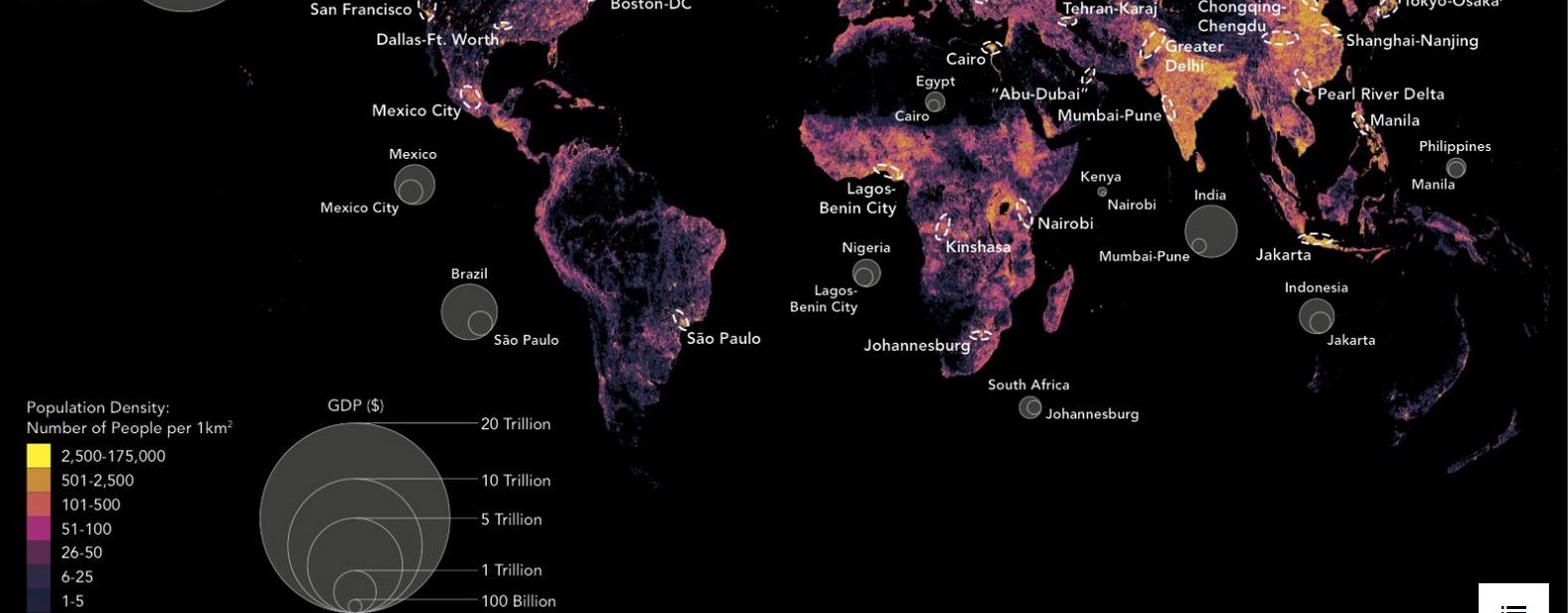
This map from my new book, Connectography,
shows the distribution of the entire world’s population, with yellow
representing the most dense areas. These zones are, not surprisingly,
where you find the dashed ovals that represent the world’s burgeoning
megacities, each of which represents a large percentage of national GDP
(indicated by the larger circles) in addition to its role as a global
hub.
Within many emerging markets such as Brazil,
Turkey, Russia, and Indonesia, the leading commercial hub or financial
center accounts for at least one-third or more of national GDP. In the
UK, London accounts for almost half Britain’s GDP. And in America, the
Boston-New York-Washington corridor and greater Los Angeles together
combine for about one-third of America’s GDP.
By
2025, there will be at least 40 such megacities. The population of the
greater Mexico City region is larger than that of Australia, as is that
of Chongqing, a collection of connected urban enclaves in China spanning
an area the size of Austria. Cities that were once hundreds of
kilometers apart have now effectively fused into massive urban
archipelagos, the largest of which is Japan’s Taiheiyo Belt that
encompasses two-thirds of Japan’s population in the Tokyo-Nagoya-Osaka
megalopolis.
China’s Pearl River delta, Greater São Paulo,
and Mumbai-Pune are also becoming more integrated through
infrastructure. At least a dozen such megacity corridors have emerged
already. China is in the process of reorganizing itself around two dozen
giant megacity clusters of up to 100 million citizens each. And yet by
2030, the second-largest city in the world behind Tokyo is expected not
to be in China, but Manila in the Philippines.
America’s rising multi-city clusters are as
significant as any of these, even if their populations are smaller.
Three in particular stand out. First, the East Coast corridor from
Boston through New York to Washington, DC contains America’s academic
brain, financial center, and political capital (the only thing missing
is a high-speed railway to serve as the regional spine).
From San Francisco to San Jose, Silicon Valley
has become one continuous low-rise stretch between I-280 and US-101 that
is home to over 6,000 technology companies that generate more than $200
billion in GDP (with a San Francisco–Los Angeles–San Diego high-speed
rail, California’s Pacific Coast would truly become the western
counterpart to the northeastern corridor. Elon Musk’s Tesla has proposed
an ultra-high-speed “Hyperloop” tunnel system for this route).
Finally,
the Dallas–Fort Worth metroplex, the largest urban cluster in the
American South, houses industry giants such as Exxon, AT&T, and
American Airlines in an economy larger than South Africa’s and is
actually building a high-speed rail (well, 120 km or ~75 miles per hour)
called the Trans-Texas Corridor that could eventually extend to the oil
capital Houston based on plans rolled out in 2014 by Texas Central
Railway and the bullet-train operator Central Japan Railway.
Great and connected cities, Saskia Sassen argues,
belong as much to global networks as to the country of their political
geography. Today the world’s top 20 richest cities have forged a
super-circuit driven by capital, talent, and services: they are home to
more than 75% of the largest companies, which in turn invest in
expanding across those cities and adding more to expand the intercity
network. Indeed, global cities have forged a league of their own, in
many ways as denationalized as Formula One racing teams, drawing talent
from around the world and amassing capital to spend on themselves while
they compete on the same circuit.
The rise of emerging market megacities as magnets
for regional wealth and talent has been the most significant
contributor to shifting the world’s focal point of economic activity.
McKinsey Global Institute research suggests that from now until 2025,
one-third of world growth will come from the key Western capitals and
emerging market megacities, one-third from the heavily populous
middle-weight cities of emerging markets, and one-third from small
cities and rural areas in developing countries.
There are far more functional cities in the world
today than there are viable states. Indeed, cities are often the
islands of governance and order in far weaker states where they extract
whatever rents they can from the surrounding country while also being
indifferent to it. This is how Lagos views Nigeria, Karachi views
Pakistan, and Mumbai views India: the less interference from the
capital, the better.
It is, of course, very difficult if not
impossible to neatly disentangle the interdependencies between city and
state, whether territorially, demographically, economically,
ecologically, or socially. That is not the point. Across the world, city
leaders and their key businesses set up Special Economic Zones and
directly recruit investors into their orbit to ensure that their workers
are hired and benefits accrue locally rather than nationally. This is
all the sovereignty they want.
To that end, entire new districts (sometimes
called aerotropolises) have sprung up around airports to evade urban
congestion and more efficiently connect to global markets and supply
chains. From Chicago’s O’Hare and Washington’s Dulles to Seoul’s Incheon
Airport, such sites have become the fastest-growing economic
geographies, underscoring the intrinsic value of connectivity. For
companies moving their headquarters into an aerotropolis, the airport is
the gateway to world markets while the nearby city, no matter how
large, is just another sales destination. Recreating the world map
according to the three dozen megacities therefore tells us much more
about where the world’s people are and money is than conventional maps
of 200 separate countries.via
Δεν υπάρχουν σχόλια :
Δημοσίευση σχολίου